Geopolitical views
Most country borders are internationally agreed-upon. But in some cases, the opinion of countries differ on which region is part of what country. For example, both India and Pakistan consider the region of Kashmir to belong entirely to their respective country, and maps in each country are expected to reflect that view. In contrast, international maps consider the Kashmir region as having disputed borders.
The HERE Vector Tile API allows rendering either one of these perspectives, so that customers can conform to local preference and/or applicable law.
Retrieve the available political views
The HERE Vector Tile API provides the politicalViews endpoint that you can use to retrieve the available geopolitical views that are available for the map.
To request the list of geopolitical views available for a map, use the /politicalViews endpoint, as shown in the following example:
https://vector.hereapi.com/v2/vectortiles/politicalViews
?apiKey=YOUR_HERE_API_KEY
For more information, see the API Reference.
When you make a politicalViews request, the response is similar to the simplified example below, listing the available political views per map layer:
{
  "base": [
    "ab",
    "ar",
    "cy",
    "eg"
  ],
  "core": [
    "ab",
    "ar",
    "cy",
    "eg"
  ]
}Note
- You can store the list of geopolitical views in your client application.
- You must refresh the list every 24 hours.
Display maps based on political views
By default, renderers display the international view. Select a political view only if your application targets an audience in a specific country that requires it.
Note
Some renderers might not support switching political views at all.
Selecting a political view depends on the renderer. For the HERE Maps API for JavaScript, you can configure this by setting a single parameter.
Visualization of political views in map data
In HERE OMV Tiles, political views are implemented by using additional kind::xx attributes (where xx represents one of the available geopolitical views). A political view-aware renderer with selected political view xx overrides the value of kind with that of kind:xx (if the latter attribute exists for a given entity) for styling the map.
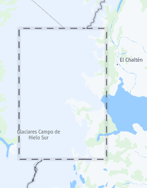
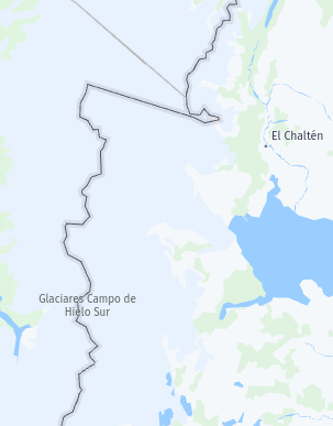
Example: the Southern Patagonian Ice Field
A user might want to view a certain location in South Patagonia, where parts of the Southern Patagonian Ice Field are in dispute between Chile and Argentina.
The data for the corresponding vector tile contains the following properties:
-
For the rectangular border around the contested region:
"properties": { "$layer": "boundaries", "kind": "disputed", "kind:ar": "unrecognized_disputed", ... } -
For an additional border passing through that region with the following properties:
"properties": {
    "$layer": "boundaries",
    "kind": "",
    "kind:ar": "country",
    ...
}
This means that for the international view (where only the kind attribute is considered) the contested rectangular region (with kind=disputed) is drawn with a dashed border to visualize it as disputed, while the border passing through that region is considered immaterial (kind without a value) and thus not drawn at all.
In contrast, in the Argentinian view (where any value in kind:ar takes precendence over the value in kind), the rectangular border (kind:ar=unrecognized_disputed) is not recognized and thus not drawn at all. Instead, the border passing through that region (with kind:ar=country) is considered to be the country border between Chile and Argentina.
The following figure illustrates the difference between maps with international and Argentinian political views, as described in the previous example:
| International View | Argentinian View |
|---|---|
 |  |