Customize map features
Further enhance user experience of your mapping applications by creating maps that visualize features related to traffic congestion, vehicle access, environmental regulations, and points of interest (POIs). By enriching your map images with these features, you assist users in making informed decisions, route planning, vehicle navigation, and compliance with local regulations.
Explore the HERE Map Image API v3 with this interactive example. Test parameters and see real-time results:
Try It OutThe following sections provide an overview for each feature type that you can include in your map images.
Optional: Get the list of additional features
To obtain the current list of feature types in the HERE Map Image API, make a request to the /features endpoint, as shown in the following example:
https://image.maps.hereapi.com/mia/v3/features
?apiKey={YOUR_API_KEY}Result: The response body is a JSON file that provides a list of map features available for a given style type. The following snippet provides a sample JSON response from the /features endpoint that shows the features available for the explore.day style:
{
   "features":{
      "explore.day":[
         {
            "modes":[
               "disabled",
               "all"
            ],
            "name":"congestion_zones"
         },
         {
            "modes":[
               "disabled",
               "all"
            ],
            "name":"environmental_zones"
         },
         {
            "modes":[
               "disabled",
               "active_and_inactive",
               "active_and_inactive_differentiated",
               "active_only",
               "permanent_only"
            ],
            "name":"vehicle_restrictions"
         },
         {
            "modes":[
               "all",
               "disabled"
            ],
            "name":"pois"
         },
         {
            "modes": [
               "asia_selected_systems",
               "all_systems",
               "disabled"
            ],
            "name":"public_transit"
         },
         {
            "modes": [
               "disabled",
               "all"
            ],
            "name": "truck_preferred_roads"
         }
      ],
      "..."
   }
}
You can use the values from the respective arrays to add or remove features from map images, as required, according to the selected map style.
Feature coverage
The following list provides countries with environmental and congestion zone coverage:
- Austria
- Belgium
- Bolivia
- Brazil
- Chile
- Colombia
- Costa Rica
- Denmark
- Ecuador
- France
- Germany
- Greece
- Indonesia
- Italy
- Mexico
- Netherlands
- Peru
- Philippines
- Portugal
- Russia
- South Korea
- Spain
- Sweden
- United Kingdom
- Vatican City
Manage points of interest
POIs, or Points of Interest, are locations on a map that are of particular interest or significance to users. These can include landmarks, tourist attractions, restaurants, hotels, gas stations, hospitals, and other places that users might want to discover or navigate to.
To explore the comprehensive library of icons used to mark various types of points of interest in the HERE Map Image API, see POI Icons in the HERE Style Editor documentation.
In the HERE Map Image API, you manage the appearance of points of interested by using the features=pois:{value} parameter, with the following values available:
all: Display points of interest in the map image. This is the default setting.disabled: Prevent the map image from displaying points of interest.
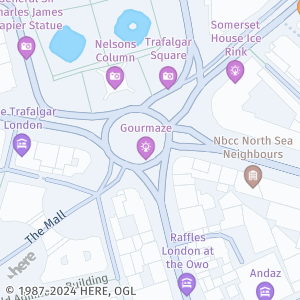
Sample request #1:
Consider the following sample request:
https://image.maps.hereapi.com/mia/v3/base/mc/center:51.507298,-0.127547;zoom=17/300x300/png8
?apikey={YOUR_API_KEY}Response:
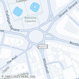
Sample request #2:
To hide points of interest, add the features=pois:disabled parameter value to your request, as shown in the following example:
https://image.maps.hereapi.com/mia/v3/base/mc/center:51.507298,-0.127547;zoom=17/300x300/png8
?apikey={YOUR_API_KEY}
&features=pois:disabledResponse:
Display congestion zones
Congestion zones indicate areas where drivers are required to pay a fee to enter or drive through during certain times of day.
In the HERE Map Image API, you manage the appearance of congestion zones by using the features=congestion_zones:{value} parameter, with the following values available:
all: Display congestion zones in the map image, if available.disabled: Do not display congestion zones. This is the default setting.
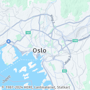
Sample request #1:
Consider the following sample request:
https://image.maps.hereapi.com/mia/v3/base/mc/center:59.918197,10.762222;zoom=11/300x300/png8
?apikey={YOUR_API_KEY}Response:
Sample request #2:
To display congestion zones in a map image, add the features parameter with congestion_zones:all value, as shown in the following example:
https://image.maps.hereapi.com/mia/v3/base/mc/center:59.918197,10.762222;zoom=11/300x300/png8
?apikey={YOUR_API_KEY}
&features=congestion_zones:allResponse:
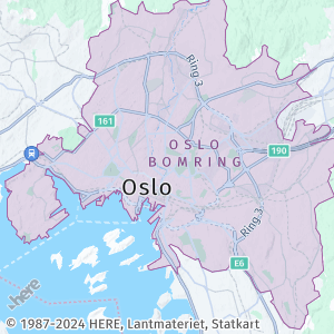
Note
In addition to highlighting the congestion zone on the map, the API also displays the name of the zone, if available, at greater zoom levels. For example, in the preceding example, the map displays the name
Oslo Bomring. This behavior is also applicable to environmental zones.
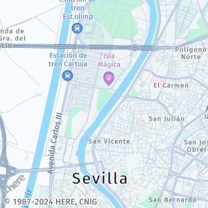
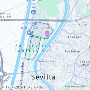
Display environmental zones
An environmental zone restricts vehicle access to only those that meet certain emissions standards. Its goal is to enhance air quality by controlling the exhaust emissions from cars. To enter the zone, drivers typically need a visible sticker on their vehicle corresponding to the required emissions standard. Motorcycles and certain special vehicles are exempt from this requirement, depending on the local regulations.
In the HERE Map Image API, you manage the appearance of environmental zones by using the features=environmental_zones:{value} parameter, with the following values available:
all: Display environmental zones in the map image, if available.disabled: Do not display environmental zones. This is the default setting.
Sample request #1:
Consider the following sample request:
https://image.maps.hereapi.com/mia/v3/base/mc/center:37.402310,-6.000860;zoom=13/300x300/png8
?apikey={YOUR_API_KEY}Response:
Sample request #2:
To display environmental zones in a map image, add the features parameter with environmental_zones:all value, as shown in the following example:
https://image.maps.hereapi.com/mia/v3/base/mc/center:37.402310,-6.000860;zoom=13/300x300/png8
?apikey={YOUR_API_KEY}
&features=environmental_zones:allResponse:
Show vehicle restrictions
Vehicle restrictions involve regulations and limitations placed on specific types of vehicles within certain areas, either on a permanent basis or during specific time periods. These restrictions commonly involve prohibiting trucks, motorcycles, or other vehicle categories in designated zones like city centers or residential areas.
In the HERE Map Image API, vehicle restrictions are visually represented by highlighting restricted roads on the map. The API also uses icons to clearly indicate the types of vehicles that are prohibited, as well as whether the restriction is applicable only during specific times of day. With this information, you can easily identify restricted areas and understand the nature of the vehicle restrictions in place.
In the HERE Map Image API, you manage the appearance of vehicle restrictions by using the features=vehicle_restrictions:{value} parameter with the following values available:
active_and_inactive: Display comprehensive view of all vehicle restrictions, regardless of their current status, which means that the image displays the ongoing and temporarily lifted or historical vehicle restrictions.active_and_inactive_differentiated: Display all vehicle restrictions with visual differentiation between active and inactive restrictions. Inactive restrictions appear grayed out on the map. This mode requiresstartTimeandendTimeparameters to evaluate time-based restrictions.active_only: Display only the active vehicle restrictions based on the specified time span. Inactive restrictions are completely hidden from the map. This mode requiresstartTimeandendTimeparameters to evaluate time-based restrictions.permanent_only: Display permanent vehicle restrictions only. This option hides all time-based vehicle restrictions, including those that are currently active. This mode is in the beta stage and might change without prior announcement.disabled: Do not display vehicle restriction data. This is the default setting.
Time-based vehicle restriction modes
The active_and_inactive_differentiated and active_only modes enable you to visualize vehicle restrictions based on specific time periods. These modes are particularly useful for logistics and route planning applications where understanding time-dependent road access is often critical.
When using these modes, you must provide both startTime and endTime parameters to represent local time:
startTime: The start of the time span for evaluating time-based vehicle restrictions. Format:YYYY-MM-DDThh:mm(RFC 3339 format without seconds or timezone).endTime: The end of the time span for evaluating time-based vehicle restrictions. Format:YYYY-MM-DDThh:mm(RFC 3339 format without seconds or timezone).
Note
The
startTimemust be less than or equal toendTime. If either parameter is missing when usingactive_and_inactive_differentiatedoractive_onlymodes, the API returns an error.
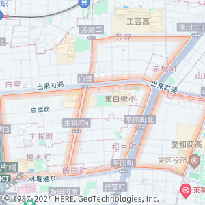
Sample request #1 (no restrictions):
Consider the following sample request:
https://image.maps.hereapi.com/mia/v3/base/mc/center:53.550936,10.008530;zoom=14/300x300/png8
?apikey={YOUR_API_KEY}Response:
Sample request #2 (active and inactive restrictions):
To display vehicle restrictions in a map image, add the features parameter with vehicle_restrictions:active_and_inactive value, as shown in the following example:
https://image.maps.hereapi.com/mia/v3/base/mc/center:53.550936,10.008530;zoom=14/300x300/png8
?apikey={YOUR_API_KEY}
&features=vehicle_restrictions:active_and_inactiveResponse:
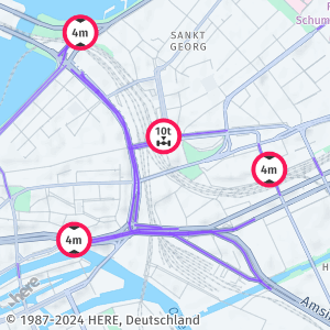
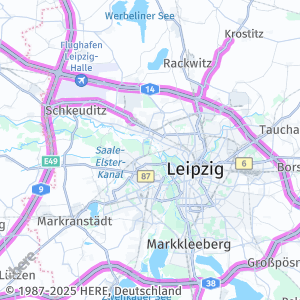
Sample request #3 (time-based differentiation for active and inactive restrictions):
To display vehicle restrictions with visual differentiation between active and inactive restrictions for a specific time period, use the vehicle_restrictions:active_and_inactive_differentiated mode with startTime and endTime parameters, as shown in the following example:
https://image.maps.hereapi.com/mia/v3/base/mc/center:52.455631,12.963431;zoom=10/300x300/png
?apikey={YOUR_API_KEY}
&features=vehicle_restrictions:active_and_inactive_differentiated
&startTime=2025-12-11T08:00
&endTime=2025-12-11T12:00Response:
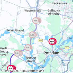
In this example, the map displays vehicle restrictions evaluated for the time window from 8:00 AM to 12:00 PM on December 11, 2025. Active restrictions appear in their standard colors, while inactive restrictions are grayed out.
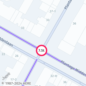
Sample request #4 (only active restrictions within a specific time window):
To display only active vehicle restrictions for a specific time period, use the vehicle_restrictions:active_only mode:
https://image.maps.hereapi.com/mia/v3/base/mc/center:52.455631,12.963431;zoom=10/300x300/png
?apikey={YOUR_API_KEY}
&features=vehicle_restrictions:active_only
&startTime=2025-12-11T08:00
&endTime=2025-12-11T12:00Response:
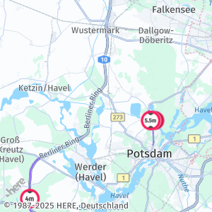
In this example, the map displays only vehicle restrictions that are active during the specified time window. Inactive restrictions are completely hidden, providing a cleaner view for route planning purposes.
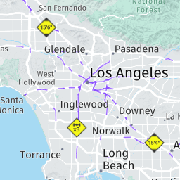
Note
To ensure a precise and recognizable depiction, map images feature vehicle restriction icons that correspond to the road signs commonly employed in a specific country. For example, see vehicle restrictions as displayed in Los Angeles, USA:
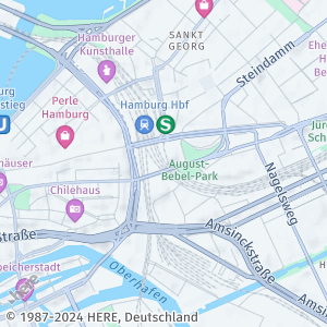
Display public transit information
Public transit information provides a clear representation of transit routes, facilitating the user's understanding of the transit network and its connections.
In the HERE Map Image API, you manage the appearance of public transit information by using the features=public_transit:{value} parameter with the following values available:
asia_selected_systems: Display only a subset of public transit lines that are considered essential for understanding the base map in Asia region.all_systems: Display and highlight all available public transit data in map images, for example, bus, tram, or underground lines.disabled: Do not display public transit data. This is the default setting.
Sample request:
To display public transit data in a map image, add the features parameter with public_transit:all_systems value, as shown in the following example:
https://image.maps.hereapi.com/mia/v3/base/mc/center:53.556046,9.993457;zoom=15/300x300/png8
?apikey={YOUR_API_KEY}
&features=public_transit:all_systemsResponse:
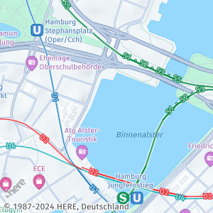
The previous example shows a map image centered on Hamburg. The image highlights the transit lines for suburban trains (S-Bahn) and underground trains (U-Bahn), in different colors.
Show low-speed zones
Applicable to the Japan map only, at zoom levels 15 and greater, this feature highlights areas with roads where the maximum speed is significantly lower in comparison to the surrounding roads. The low-speed areas usually include narrow roads without footpaths, and free from trees or utility posts, where vehicles and pedestrians coexist closely.
You can manage the appearance of low-speed zones by using the features=low_speed_zones:{value} parameter, with the following values available:
all: Display low-speed zones in the map image, if available.disabled: Do not display low-speed zones. This is the default setting.
Sample request:
To display low-speed zones in a map image, add the features parameter with low_speed_zones:all value, as shown in the following example:
https://image.maps.hereapi.com/mia/v3/base/mc/center:35.182727/136.920270;zoom=15/300x300/png8
?apikey={YOUR_API_KEY}
&features=low_speed_zones:allResponse:
The previous map shows an area in Nagoya, Japan, with several low-speed zones highlighted.
Display truck preferred roads
By visualizing truck preferred roads, you enable logistics applications, fleet management systems, and navigation tools to provide drivers with routes that are better suited for commercial vehicles.
This feature is important for applications that serve the logistics and transportation industries, where routing commercial vehicles along appropriate roads can improve operational efficiency and reduce the risk of encountering roads with restrictions or inadequate infrastructure for large vehicles.
In the HERE Map Image API, you manage the appearance of truck preferred roads by using the features=truck_preferred_roads:{value} parameter with the following values available:
all: Display truck preferred roads in the map image, if available.disabled: Do not display truck preferred roads. This is the default setting.
Sample request:
To display truck preferred roads in a map image, add the features parameter with truck_preferred_roads:all value, as shown in the following example:
https://image.maps.hereapi.com/mia/v3/base/mc/center:51.362254,12.323825;zoom=10/300x300/png
?apikey={YOUR_API_KEY}
&features=truck_preferred_roads:allResponse:
The map image displays truck preferred roads highlighted with distinct visual styling, making them easily identifiable from the regular road network, as shown in the following figure:
Combine multiple features in a single map image
To offer a more comprehensive and informative depiction of the location or area you are mapping, you can specify multiple features parameters. For example, if your mapping application supports greater zoom levels, you can combine the inclusion of vehicle restrictions with the exclusion of points of interest (POIs). This enables you to create map images that exclusively highlight vehicle restrictions while eliminating any potentially distracting POI markers.
Sample request:
The following sample request demonstrates this potential use case:
https://image.maps.hereapi.com/mia/v3/base/mc/center:52.366547,4.911802;zoom=18/300x300/png8
?apikey={YOUR_API_KEY}
&features=vehicle_restrictions:active_and_inactive,pois:disabledResponse:
The map image showcases vehicle restrictions while suppressing POI markers, as shown in the following figure:
To illustrate the impact of disabling POIs, the following figure presents the same map image, but with POIs enabled:
By customizing the map in this way, you can provide a clearer and more focused representation of the specific information you want to convey to your users.
Next steps
- To explore all supported endpoints and parameters, see the API Reference.
- To gain more hands-on experience with the HERE Map Image API see the
Tutorialssection of this guide.