
transit V2
Content: transit
Geometry: line, polygon
Zoom: 5–17
The transit layer provides information about public transportation systems, such as buses, trains, subways, and other modes of public transit. The features of this layer enable developers to integrate public transit data into applications or services, allowing users to plan routes, view schedules, and obtain real-time information about public transportation options.
The following figure illustrates sample features of the transit layer rendered from the data:
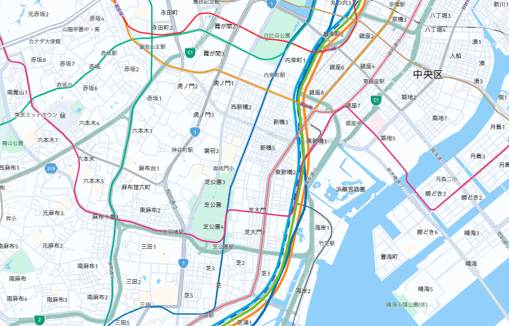
Transit line features become visible from zoom level 6 onwards, while platform polygons are added at zoom level 14 and
higher.
To optimize efficiency, there are 2 levels of features consolidation (LOC):
- LOC 1: There is one line geometry feature for each pair of
kindandkind_detailvalues. It contains all line names of thiskindandkind_detailon this segment concatenated into one string. This LOC can be used to display a less detailed network (one line perkind_detail) and to display all concatenated labels for thiskind_detail. These concatenated labels can even be used to display all well-formatted labels as a row for LOC 2 lines. - LOC 2: There is one additional line geometry feature for each PT line segment which has the same
kind,kind_detail,colour. In case several PT lines with the same operator supplied colour/type on the same segment, the geometry is merged into one line and all line names are added as a list. Client can do simple parallel line rendering by multiplying the logical offset with the pixel offset defined in the style.
Every feature in the transit layer includes a set of properties that define it, regardless of the specific transit type it represents.
Consider the following sample parameters for a transit features representing common transit route segment line geometry.
The Tohoku Line intercity line is represented by the color #00BB85, while the Takasaki Line and Utsunomiya Line intercity lines are represented by the color #FF871C:
LOC 1:
...
"kind": "train",
"kind_detail": "intercity",
"min_zoom": 8,
"sort_rank": 436,
"name": "宇都宮線  ·  東北本線  ·  高崎線",
"name:en": "Takasaki Line  ·  Tohoku Line  ·  Utsunomiya Line",
"name:ja": "宇都宮線  ·  東北本線  ·  高崎線",
"name:ko": "다카사키 선  ·  도호쿠 본선  ·  우쓰노미야 선",
"name:zh": "宇都宮線  ·  東北本線  ·  高崎線",
...
LOC 2:
...
"source": "ipc",
"kind": "train",
"kind_detail": "intercity",
"num_lines": 2,
"min_zoom": 8,
"logical_offset": 0,
"sort_rank": 436,
"ref": ";東北本線;",
"name": "東北本線",
"name:en": "Tohoku Line",
"name:ja": "東北本線",
"name:ko": "도호쿠 본선",
"name:zh": "東北本線",
"colour": "#00BB85",
"direction": "F",
"operator": "101037_a7e604b",
......
"source": "ipc",
"kind": "train",
"kind_detail": "intercity",
"num_lines": 2,
"min_zoom": 8,
"logical_offset": 1,
"sort_rank": 436,
"ref": ";高崎線;宇都宮線;",
"name": "宇都宮線 · 高崎線",
"name:en": "Takasaki Line · Utsunomiya Line",
"name:ja": "宇都宮線 · 高崎線",
"name:ko": "다카사키 선 · 우쓰노미야 선",
"name:zh": "宇都宮線 · 高崎線",
"colour": "#FF871C",
"direction": "F;F",
"operator": "101037_a7e604b;101037_a7e604b",
...Properties
kind | kind_detail | colour | direction | logical_offset | name | name:{language_code} | num_lines | operator | ref | text_colour
Properties specific to Japan - core map
Common properties
Common properties specific to Japan - core map
kind
Type: string
Always present
The general type of transit feature.
Values
| Value | Geometry | Zoom | Description |
|---|---|---|---|
aerial | line | 10–17 | A transportation system that operates above ground level, such as an aerial tramway or gondola. |
ferry | line | 10–17 | A transportation system that operates short- and long-distance boat services. |
funicular | line | 10–17 | A transportation system that uses cable-operated cars on steep inclines. |
light_rail | line | 8–17 | A type of urban rail transit that operates with light capacity and shares tracks with other vehicles. The actual sort_rank value depends on the specific kind_detail for this feature instance. |
monorail | line | 10–17 | A railway system where the trains run on a single rail. |
subway | line | 8–17 | An underground or elevated railway system typically found in urban areas. |
train | line | 5–17 | A general term referring to a mode of transportation that runs on tracks, typically used for intercity or regional travel. The actual sort_rank value depends on the specific kind_detail for this feature instance. |
Values specific to Japan - core map
| Value | Geometry | Zoom | Description |
|---|---|---|---|
subway_station_platform | polygon | 14–17 | (sort_rank: 385) - Platform of a subway station. |
kind_detail
Type: string
Present when kind is: aerial, ferry, funicular, light_rail, monorail, subway, train
This property provides additional details about the kind of transit feature. This parameter is relevant only within the context of the line geometry type.
| Value | Description | Associated kind |
|---|---|---|
aerial | Denotes aerial cable car or gondola lines for the aerial kind. | aerial |
ferry | Denotes short- and long-distance boat lines for the ferry kind. | ferry |
funicular | Indicates funicular lines for the funicular kind. | funicular |
high_speed | Indicates high-speed railroad lines with the train kind. | train |
intercity | Represents intercity railroad lines with the train kind. | train |
monorail | Denotes monorail lines for the monorail kind. | monorail |
regional | Denotes regional railroad lines with the train kind. | train |
suburban | Indicates suburban rail lines for the light_rail kind. | light_rail |
subway | Represents subway lines for the subway kind. | subway |
touristic | Indicates touristic railroad lines with the train kind. | train |
tram | Represents tram lines for the light_rail kind. | light_rail |
airport_terminal | Indicates airport terminal lines for the train kind. | train |
colour
Type: string
Optional
A hex value representing the color for the routes valid on this line. In the example, there are 3 intercity routes on a transit segment with 2 different colors. There is separate feature for each color. The first intercity line feature with color #00BB85 corresponds to the 東北本線 (Tohoku Line) route, and the second feature with color #FF871C corresponds to the 宇都宮線, 高崎線 (Takasaki Line, Utsunomiya Line) routes.
direction
Type: string
Array
Optional
The parameter direction specifies all the directions of the routes that are valid on a line segment for particular line color. The values are provided as semicolon-separated values. The following conventions are used:
logical_offset
Type: int
Range: 0–21
Present when kind is: aerial, ferry, funicular, light_rail, monorail, subway, train
A line offset calculated across all lines in a segment with the same kind and kind_detail, in the range from 0 to num_lines. In the example, the first intercity line feature has \"logical_offset\": 0, and the second feature has \"logical_offset\": 1. This parameter is relevant only within the context of the line geometry type.
name
Type: string
Present when kind is: aerial, ferry, funicular, light_rail, monorail, subway, train
A dot-separated sorted list of all the route names valid on this transit line segment. In the example, the line has 3 intercity routes: 宇都宮線, 東北本線, and 高崎線. This parameter is relevant only within the context of the line geometry type. A dot-separated list of the route names valid on this transit line segment with the same colour. In the example, the first intercity line feature has 1 intercity route: 東北本線, and the second feature has 2 routes: 宇都宮線 and 高崎線. This parameter is relevant only within the context of the line geometry type. It has alphabetical order.
name:{language_code}
Type: string
Present when kind is: aerial, ferry, funicular, light_rail, monorail, subway, train
Localized dot-separated sorted list of the route names. For example, in English, the routes from the example are referred to as Takasaki Line, Tohoku Line, and Utsunomiya Line. The same routes are also provided in other languages as identified by ISO 639-1 two-letter language codes.
num_lines
Type: int
Range: ≥ 1
Present when kind is: aerial, ferry, funicular, light_rail, monorail, subway, train
Count of line features in a segment with the same kind and kind_detail.
operator
Type: string
Array
Optional
A semicolon-separated list of operator IDs for the routes valid on this line segment for particular color. For example, \"operator\": \"101037_a7e604b;101037_a7e604b\". The first operator ID corresponds to the operator of the 高崎線 (Takasaki Line) route, and the second operator ID corresponds to the operator of the 宇都宮線 (Utsunomiya Line) route.
ref
Type: string
Array
Optional
A semicolon-separated list of route names valid on this transit line segment with the same colour in order according to source. This parameter is relevant only within the context of the line geometry type.
text_colour
Type: string
Array
Optional
Colors used for drawing the text of reference values for the routes valid on this line. It follows the same format as colour. This parameter is relevant only within the context of the line geometry type.
Properties specific to Japan - core map
height
Type: float
Present when kind is: subway_station_platform · Present when zoom is: 14, 15, 16
Example values: 12.400000, 12.000000, 24.800000, 13.400000, 17.800000
Common properties
sort_rank
Type: int
Always present
The ordering of features, which determines which features are rendered "on top of" other features, can be an important issue when rendering maps. To assist map rendering, there is a sort_rank property on some features that suggests in what order the features should appear.
A feature with a higher sort_rank value is displayed on top of feature with a lower sort_rank value.
Values
Values specific to Japan - core map
| Value | Associated kind |
|---|---|
385 | subway_station_platform |
min_zoom
See min_zoom.
Common properties specific to Japan - core map
source
See source.
Updated last month