

roads
Content: default, advanced_roads
Geometry: line, point
Zoom: 3–17
The roads layer contains comprehensive transportation data, encompassing various types like highways, major and minor roads, paths, railways, and ferries. For example, this dataset is important in fleet management applications, ensuring vehicles comply with regulations by following approved routes and restrictions.
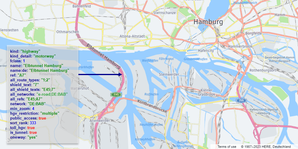
The following figure illustrates an example of a road rendered from vector data:
Note
When working with the
roadslayer, consider the following design features and restrictions:
- To accurately represent layered overpasses, bridges, and tunnels, ensure to apply the
sort_rankfor proper layering.- To improve performance, some road segments are merged at low and medium zoom values. This means that certain properties are removed at those zoom levels, for example,
is_bridgeandis_tunnel,name,network,oneway, andref. The exact zoom level at which a property is no longer relevant varies by feature class.- The
advanced_roadscontent expands upon theroadslayer by providing specialized information specifically designed to meet the requirements of heavy goods vehicles (HGVs).
Properties
kind | kind_detail | all_networks | all_refs | all_route_types | all_shield_texts | delivery_road | exit_name | fclass | is_bridge | is_link | has_polygonal_geometry | is_tunnel | name | name:{language_code} | network | oneway | pedestrian_zone | private | public_access | ref | service | shield_text | surface | toll | translit:{language_code} | under_construction | z_level
Properties specific to content=advanced_roads
all_hgv_applied_to_delivery | all_hgv_restriction_shield_text | all_hgv_restrictions | all_hgv_time_restrictions | all_tpr | hgv | hgv_applied_to_delivery | hgv_direction | hgv_gross_weight_mass | hgv_restriction | hgv_restriction_shield_text | hgv_road_kind | hgv_road_kind_detail | hgv_time_restrictions | toll_hgv | toll_hgv_time_restrictions
Properties specific to Japan - core map
is_present_in_city | is_present_in_landuse
Common properties
Common properties specific to Japan - core map
kind
Type: string
Always present
The general type of road. For more information, see Kind values for the roads layer.
Values
| Value | Geometry | Zoom | Description |
|---|---|---|---|
aerialway | line | 10–17 | Represents aerial transportation systems such as gondolas, chairlifts, or cable cars. |
ferry | line | 7–17 | Denotes ferry routes or paths across bodies of water. Represented as lines indicating ferry travel routes. |
highway | line | 3–17 | Represents roads, streets, or thoroughfares designed for vehicular traffic. |
major_road | line | 6–17 | Represents roads of significant importance or size within a road network. Often characterized by higher traffic volume or crucial connections. |
minor_road | line | 10–17 | Denotes roads of lesser significance or size within a road network. Typically includes smaller streets or roads with lower traffic volume. |
path | line | 10–17 | Represents pathways or trails designated for pedestrians, cyclists, or specific non-motorized transport. |
piste | line | 12–17 | Denotes ski slopes or trails for skiing or snowboarding. |
rail | line | 7–17 | Depicts railway tracks or routes for trains or other rail transport. |
Values specific to content=advanced_roads
content=advanced_roads| Value | Geometry | Zoom | Description |
|---|---|---|---|
hgv_restriction | point | 7–17 |
kind_detail
Type: string
Present when kind is: aerialway, ferry, highway, major_road, minor_road, path, piste, rail
Additional details about the kind of road. For example, the minor_road kind can have residential, service, or unclassified kind_detail values. For more information, see kind_detail values for the roads layer.
Values
| Value | Associated kind |
|---|---|
trunk | highway |
motorway | highway |
primary | major_road |
tertiary | major_road |
residential | minor_road |
service | minor_road |
chair_lift | aerialway |
downhill | piste |
ferry | ferry |
footway | path |
pedestrian | path |
rail | rail |
secondary | major_road |
Values specific to Japan - core map
all_networks
Type: string
Array
Optional
All the networks associated with the particular road. These networks are presented as a collection of network values separated by semicolons. For further details, see the network property definition.
all_refs
Type: string
Array
Optional
Encompasses all the references associated with this road. These references are presented as a sequence of ref values separated by semicolons. For further details, see the ref property definition. ## Conditional properties Some roads features include properties that provide additional information, for example, whether a particular road is a part of a tunnel, a bridge, and so on.
Note
These properties are referred to as
common-optionalproperties in the Tilezen schema. For more information, see Tile layers.
all_route_types
Type: int|string
Array: element type: int
Present when kind is: ferry, highway, major_road, minor_road, path, rail · Present when kind_detail is: ferry, footway, motorway, pedestrian, primary, rail, residential, secondary, service, tertiary, trunk · Present when zoom is: 5, 6, 7, 8, 9, 10, 11, 12, 13, 14, 15, 16
Various route types that encompass the specified road. These types are represented as a series of numeric codes, separated by semicolons. These codes are used for shield styling based on the country's specifications.
all_shield_texts
Type: string
Array
Optional
Lists all the shield texts associated with the particular road. These texts are presented as a collection of shield_text values separated by semicolons. For further details, see the shield_text property definition.
delivery_road
Type: flag
Present when kind is: minor_road, path · Present when kind_detail is: pedestrian, residential, service · Present when zoom is: 12, 13, 14, 15, 16
Set to true if access to the element is only allowed when making deliveries to it.
exit_name
Type: string
Present when kind is: major_road, minor_road, path, highway
The name of a motorway junction or exit, if available. Useful for navigation applications that display junction names on route guidance panels.
fclass
Type: int
Present when kind is: ferry, highway, major_road, minor_road, path · Present when kind_detail is: ferry, footway, motorway, pedestrian, primary, residential, secondary, tertiary, trunk
This property indicates a functional class numeric value for roads with kind_detail:motorway and kind_detail:motorway_link.
| Tilezen Road properties | Functional Class |
|---|---|
kind is highway and kind_detail is motorway and fclass is N | N |
kind is highway and kind_detail is trunk | 1 |
kind is highway, kind_detail is motorway_link, is_link is true and any fclass | 1 |
kind is major_road and kind_detail is primary | 2 |
kind is major_road and kind_detail is secondary | 3 |
kind is major_road and kind_detail is tertiary | 4 |
kind is minor_road and kind_detail is (residential or service) | 5 |
kind is path and kind_detail is (footway or pedestrian) | 5 |
| Tilezen Road properties | Functional Class |
|---|---|
kind is highway, and kind_detail is motorway | 1 |
kind is highway and kind_detail is motorway | 2 |
kind is highway and kind_detail is motorway | 3 |
kind is major_road and kind_detail is primary | 3 |
kind is major_road and kind_detail is secondary | 4 |
kind is major_road and kind_detail is secondary | 5 |
kind is major_road and kind_detail is tertiary | 6 |
kind is major_road and kind_detail is tertiary | 7 |
kind is minor_road and kind_detail is residential | 8 |
kind is path and kind_detail is pedestrian | 8 |
kind is minor and kind_detail is (residential or service) | 9 |
kind is minor_road and kind_detail is (residential or service) | 10 |
kind is path and kind_detail is (footway or pedestrian) | 10 |
kind is minor_road and kind_detail is (residential or service) | 11 |
kind is path and kind_detail is (footway or pedestrian) | 11 |
Values
| Value |
|---|
1 |
2 |
3 |
4 |
5 |
Values specific to Japan - core map
| Value |
|---|
6 |
7 |
8 |
is_bridge
Type: flag
Present when kind is: ferry, highway, major_road, minor_road, path, rail · Present when kind_detail is: ferry, footway, motorway, pedestrian, primary, rail, residential, secondary, service, tertiary, trunk
Set to true and present only if the road is part of a bridge.
is_link
Type: flag
Present when kind is: highway, major_road, minor_road · Present when kind_detail is: motorway, primary, residential, secondary, service, tertiary, trunk
Set to true and present only if the road is part of a highway link or ramp.
has_polygonal_geometry
Type: flag
Present when kind is: minor_road, highway, major_road, path, ferry, piste, rail · Present when kind_detail is: residential, service, trunk, tertiary, motorway, secondary, pedestrian, primary, footway, ferry, downhill, rail
Indicates whether the road has polygonal representation available in HERE data. The polygonal data itself is not part of the OMV.
is_tunnel
Type: flag
Present when kind is: highway, major_road, minor_road, path, rail · Present when kind_detail is: footway, motorway, pedestrian, primary, rail, residential, secondary, service, speed_rail, tertiary, trunk
Set to true and present only if the road is part of a tunnel.
name
Type: string
Present when kind is: aerialway, ferry, highway, major_road, minor_road, path, piste, rail
The common local name for the road feature, in the local language script. For more information, see Feature names.
name:{language_code}
Type: string
Optional
The name of the feature in the specified language. If no data is available for the requested language code, the value may be compiled from an English or Latin transliteration of existing language representations. For more information, see Name localization.
network
Type: string
Optional
Useful for shields and road selections, for example, US:I for the United States Interstate network. The property contains only road network types. For a full list of available values, see Road network values.
oneway
Type: string
Present when kind is: aerialway, ferry, highway, major_road, minor_road, path, piste, rail · Present when kind_detail is: chair_lift, downhill, ferry, footway, motorway, pedestrian, primary, rail, residential, secondary, service, tertiary, trunk · Present when zoom is: 14, 15, 16
An optional property that indicates if traffic is one-way and travels in the same direction as the linestring. This property can only have the yes value.
| Value |
|---|
yes |
pedestrian_zone
Type: flag
Present when kind is: ferry, path · Present when kind_detail is: ferry, pedestrian
Set to true if a pedestrian road is part of a pedestrian zone.
private
Type: flag
Present when kind is: aerialway, ferry, highway, major_road, minor_road, path, piste, rail · Present when kind_detail is: chair_lift, downhill, ferry, footway, motorway, pedestrian, rail, residential, secondary, service, tertiary
Set to true if the element is not open to the public, and access is only granted with individual permission.
public_access
Type: flag
Present when kind is: aerialway, ferry, highway, major_road, minor_road, path, piste, rail · Present when kind_detail is: chair_lift, downhill, ferry, footway, motorway, pedestrian, primary, rail, residential, secondary, service, tertiary, trunk
Set to true if the public has an official and legally protected right to access the element.
ref
Type: string
Optional
A commonly used reference for a roads feature, for example, \"I 90\" for Interstate 90. To use with shields, see the network and shield_text property definitions.
service
Type: string
Present when kind is: minor_road · Present when kind_detail is: service
| Value |
|---|
parking_aisle |
shield_text
Type: string
Optional
Refers to the text displayed on a road shield. For example, consider the I 90 road, which belongs to the US:I network and has a shield_text of 90. While the ref value (I 90) contains additional information, it might not be as suitable for direct shield display without further processing. For certain roads, this property can contain non-numeric characters. For example, the UK's M1 motorway has a shield_text value of M1 rather than just 1.
surface
Type: string
Present when kind is: aerialway, ferry, highway, major_road, minor_road, path, piste · Present when kind_detail is: chair_lift, downhill, ferry, footway, pedestrian, primary, residential, secondary, service, tertiary, trunk
Set to unpaved and present only if the road is unpaved.
| Value |
|---|
unpaved |
toll
Type: flag
Present when kind is: highway, major_road, minor_road, path · Present when kind_detail is: motorway, pedestrian, primary, residential, secondary, service, tertiary, trunk
An optional boolean property that indicates if a fee must be paid by general traffic to use the feature. This property can only have the true value.
translit:{language_code}
Type: string
Optional
The localized transliteration of the default name (name). For more information, see Name localization.
under_construction
Type: flag
Present when kind is: highway, major_road, minor_road, path, rail · Present when kind_detail is: motorway, pedestrian, primary, rail, residential, secondary, service, tertiary, trunk
Set to true and present when the road is under construction and may not be accessible to some or all types of traffic.
z_level
Type: int
Present when kind is: aerialway, ferry, highway, major_road, minor_road, path, piste, rail · Present when kind_detail is: chair_lift, downhill, ferry, footway, motorway, pedestrian, primary, rail, residential, secondary, service, tertiary, trunk · Present when zoom is: 14, 15, 16
An optional property to manage the loading and rendering order of features on the map, mirroring the above/below relationships observed in reality. If the property is absent, it defaults to a value of 0. Roads with higher z_level should be drawn after roads with smaller values. The current allowable range for z_level values is -4 to 5. The following figure illustrates a map featuring sample features with varying z_level values. This example showcases how features with a higher z_level value are depicted "above" features with a lower z_level value. !Sample z_levels
| Value |
|---|
-3 |
-2 |
-1 |
1 |
2 |
3 |
Properties specific to content=advanced_roads
content=advanced_roadsall_hgv_applied_to_delivery
Type: string
Array
Present when kind is: ferry, highway, major_road, minor_road, path, rail · Present when kind_detail is: ferry, footway, motorway, pedestrian, primary, rail, residential, secondary, service, tertiary, trunk · Present when zoom is: 7, 8, 9, 10, 11, 12, 13, 14, 15, 16
An optional property for roads with multiple restrictions and contains a semicolon-separated (;) list of hgv_applied_to_delivery values (only for hgv_restriction : multiple).
all_hgv_restriction_shield_text
Type: string
Array
Optional
This property is always paired with the all_hgv_restrictions property and contains a semicolon-separated (;) list of hgv_restriction_shield_text values (only for hgv_restriction : multiple).
all_hgv_restrictions
Type: string
Array
Optional
This property is always paired with the all_shield_texts property and contains a semicolon-separated (;) list of hgv_restriction values (only for hgv_restriction : multiple).
all_hgv_time_restrictions
Type: string
Present when kind is: ferry, highway, major_road, minor_road, path, rail · Present when kind_detail is: ferry, footway, motorway, pedestrian, primary, rail, residential, secondary, service, tertiary, trunk · Present when zoom is: 7, 8, 9, 10, 11, 12, 13, 14, 15, 16
This property is always paired with the all_hgv_restrictions property and contains a semicolon-separated (;) list of hgv_time_restrictions values (only for hgv_restriction : multiple).
all_tpr
Type: string
Array: element type: int
Optional
An optional property for designating roads or pathways that are approved and recommended for heavy vehicle traffic. It contains a semicolon-separated (;) list of tpr codes. For example, all_tpr: \"21;27;30\" means that the road is suggested for the following heavy vehicle types: 21 - PBS Level 2A, 27 - B-Double, not exceeding 23 meters in length under General Mass Limits (GML), and 30 - B-Double, not exceeding 26 meters in length under Higher Mass Limits (HML). \ Supported values with descriptions are available by link.
hgv
Type: string
Present when kind is: ferry, highway, major_road, minor_road, path, rail · Present when kind_detail is: ferry, motorway, pedestrian, primary, rail, residential, secondary, service, tertiary, trunk
Indicates access for general heavy goods vehicles. Available only for Line geometries. Values include: no, delivery.
Note If the
hgvproperty has the valueno, then the road has nohgv_restrictionandhgv_restriction_shield_textproperties. In other cases, the road can have thehgv_restrictionandhgv_restriction_shield_textproperties. Thedeliveryvalue indicates that the road is forbidden for trucks making transit trips, but allows deliveries.
| Value |
|---|
delivery |
no |
hgv_applied_to_delivery
Type: bool
Present when kind is: ferry, hgv_restriction, highway, major_road, minor_road, path, rail
An optional property to indicate whether restrictions apply to delivery traffic as well as through traffic. This property is present only when its value is false.
| Value |
|---|
false |
hgv_direction
Type: string
Present when kind is: ferry, hgv_restriction, highway, major_road, minor_road, path
This optional property indicates that the restriction is one-way and specifies the direction in relation to the road line. This property can be forward F or backward B.
| Value |
|---|
B |
F |
hgv_gross_weight_mass
Type: bool
Present when kind is: ferry, hgv_restriction, highway, major_road, minor_road, path, rail
This is an optional property that is always paired with the hgv_restriction property set to weight and specifies the type of weight restriction. When true the property indicates a Gross Vehicle Mass (GVM) restriction. If false, it indicates a current weight restriction. The absence of this property results in an undetermined weight restriction type.
Example values: false, true
hgv_restriction
Type: string
Present when kind is: ferry, hgv_restriction, highway, major_road, minor_road, path, rail
This optional property indicates limitations to heavy goods vehicle truck access. Available for both Point and Line geometries. For more information, see hgv_restriction values and the hgv_restriction_shield_text property definition.
| Value | Description |
|---|---|
axles | Number of axles restriction. |
axles_group_single_axle | |
axles_group_tandem_axle | |
axles_group_triple_axle | |
hazmat | Restriction for vehicles that carry hazardous materials. |
height | Height restriction. |
kpra | Kingpin to rear axle length restriction. |
length | Length restriction. |
multiple | Used when more than one restriction is present (represented by points along the line, where every point indicates a specific restriction that applies to this road). |
other | Other restrictions. |
trailers | Trailers restriction. |
weight | Vehicle weight, including trailers and shipped goods when loaded at capacity. |
width | Width restriction. |
wpa | |
wpag_quad_axle | Indicates the weight limit per axle group for HGVs with quad axle groups. |
wpag_quint_axle | Indicates the weight limit per axle group for HGVs with quint axle groups. |
wpag_single_axle | Indicates the weight limit per axle group for HGVs with a single axle group. |
wpag_tandem_axle | Indicates the weight limit per axle group for HGVs with tandem axle groups. |
wpag_triple_axle | Indicates the weight limit per axle group for HGVs with triple axle groups. |
wpan_five_axles | Specifies the weight limit for HGVs with five axles. |
wpan_five_or_more_axles | Specifies the weight limit for HGVs with five or more axles. |
wpan_four_axles | Specifies the weight limit for HGVs with four axles. |
wpan_four_or_more_axles | Specifies the weight limit for HGVs with four or more axles. |
wpan_seven_axles | Specifies the weight limit for HGVs with seven axles. |
wpan_six_axles | Specifies the weight limit for HGVs with six axles. |
wpan_six_or_more_axles | Specifies the weight limit for HGVs with six or more axles. |
wpan_three_axles | Specifies the weight limit for HGVs with three axles. |
wpan_three_or_more_axles | Specifies the weight limit for HGVs with three or more axles. |
wpan_two_axles | Specifies the weight limit for HGVs with two axles. |
wpan_two_or_more_axles | Specifies the weight limit for HGVs with two or more axles. |
hgv_restriction_shield_text
Type: string
Optional
This optional property is always paired with hgv_restriction and indicates limitations to heavy goods vehicle access. Because the units are different per restriction, an abbreviation is provided next to the value, for example, 5.1m or 16'9\" (US), 4t or 4.4 T (US). Such values are specified with one decimal precision, but the value of 5.0m is given as 5m. For more information, see hgv_restriction_shield_text values.
hgv_road_kind
Type: string
Present when kind is: hgv_restriction
This property is available only for Point features and mirrors the kind property of the road the restriction is applied to.
| Value |
|---|
ferry |
highway |
major_road |
minor_road |
path |
rail |
hgv_road_kind_detail
Type: string
Present when kind is: hgv_restriction
This property is available only for Point features and mirrors the kind_detail property of the road the restriction is applied to.
| Value |
|---|
ferry |
footway |
motorway |
pedestrian |
primary |
rail |
residential |
secondary |
service |
tertiary |
trunk |
hgv_time_restrictions
Type: string
Present when kind is: ferry, hgv_restriction, highway, major_road, minor_road, path
This optional property specifies when heavy goods vehicle access is restricted. For more information, see hgv_time_restrictions values.
toll_hgv
Type: flag
Present when kind is: ferry, highway, major_road, minor_road, path, rail · Present when kind_detail is: ferry, motorway, pedestrian, primary, rail, residential, secondary, service, tertiary, trunk
An optional boolean property that indicates whether a toll applies to certain classes of heavy goods vehicles. This property is present only when its value is true.
toll_hgv_time_restrictions
Type: string
Present when kind is: ferry, highway, major_road, minor_road, path · Present when kind_detail is: ferry, motorway, pedestrian, primary, residential, secondary, service, tertiary, trunk
An optional property that is always paired with the toll_hgv property and indicates the time period when a HGV access fee is collected.
Properties specific to Japan - core map
is_present_in_city
Type: flag
Present when kind is: aerialway, rail · Present when kind_detail is: cable_car, gondola, light_rail, monorail, private_rail, rail, speed_rail, state_rail, subway
Set to true if the rail is integrated into the city rail network. This property is available exclusively within the core map parameter, with restricted coverage applicable to Japan at zoom 14 and higher. Rails possessing this property are solely employed for labeling purposes when displaying line geometries derived from the city rail network. This property is applicable only to the rail kind.
is_present_in_landuse
Type: flag
Present when kind is: ferry, highway, major_road, minor_road, path · Present when kind_detail is: ferry, footway, motorway, pedestrian, primary, residential, secondary, tertiary, trunk
Indicates whether the road has a detailed polygonal representation within various landuse categories, such as expressway, urban_expressway, national_road, major_road, or other_road. Alternatively, it might be formed as an area not covered by specific landuse categories for minor roads. This property exists solely within the core map parameter and has limited coverage for Japan at zoom level 14. It facilitates the filtering of road centerlines while displaying comprehensive road geometries derived from landuse data. For more information, see Polygonal roads.
Common properties
min_zoom
See min_zoom.
sort_rank
Type: int
Optional
The ordering of features, which determines which features are rendered "on top of" other features, can be an important issue when rendering maps. To assist map rendering, there is a sort_rank property on some features that suggests in what order the features should appear.
A feature with a higher sort_rank value is displayed on top of feature with a lower sort_rank value.
Values
| Value | Associated kind |
|---|---|
304 | path |
310 | minor_road |
327 | major_road |
329 | major_road |
330 | major_road |
331 | highway |
332 | rail |
333 | highway |
354 | path |
355 | ferry, piste |
360 | minor_road |
377 | major_road |
379 | major_road |
380 | major_road |
381 | highway |
382 | rail |
383 | highway |
404 | path |
405 | ferry |
410 | minor_road |
427 | major_road |
429 | major_road |
430 | major_road |
431 | highway |
432 | rail |
433 | highway |
442 | aerialway |
Values specific to Japan - core map
Common properties specific to Japan - core map
source
See source.
Updated 2 months ago