

landuse
Content: default
Geometry: line, point, polygon
Zoom: 0–17
Land use refers to the way humans utilize the land for different economic and cultural activities, including agriculture, residential living, industrial operations, mining, and recreation.
In HERE Vector Tile API, the landuse layer provides information about the various types of land use in a particular geographic region. This layer is crucial for map developers because it enables distinguishing between different land use types with ease and provides users with a better understanding of the geographic areas they are exploring.
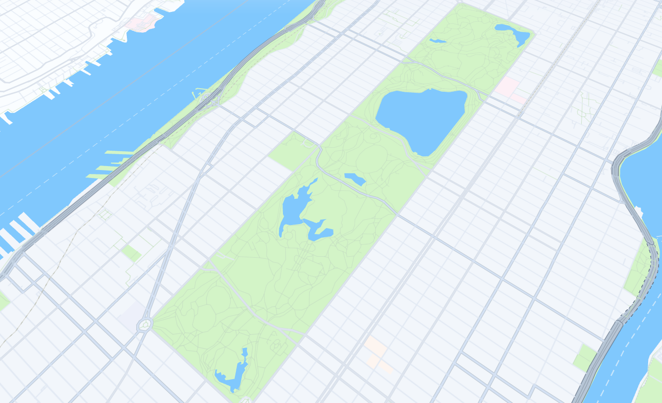
The following figure illustrates sample features of the landuse layer when rendered:
Properties
kind | kind_detail | area | name | name:{language_code} | translit:{language_code}
Properties specific to Japan - core map
Common properties
Common properties specific to Japan - core map
kind
Type: string
Always present
The kind of the landuse feature.
At zoom levels lower than 12, certain types of landuse features are consolidated to reduce unnecessary detail and encourage adjacent landuse features to merge together more seamlessly.
Note
The
idproperty is not available for consolidated landuse features.
Values
| Value | Geometry | Zoom | Description |
|---|---|---|---|
aerodrome | point, polygon | 9–17 | Airports and airstrips. |
allotments | point, polygon | 12–17 | Plots of land used for growing vegetables. |
beach | point, polygon | 9–17 | Sandy or pebble-covered shorelines. |
cemetery | point, polygon | 12–17 | Burial sites and cemeteries. |
commercial | point, polygon | 12–17 | Retail and commercial centers. Consolidated into urban_area at zoom levels lower than 12. |
desert | point, polygon | 0–17 | Arid and uninhabitable land. |
forest | point, polygon | 0–17 | Woodlands. |
glacier | point, polygon | 0–17 | Large area of ice. |
golf_course | point, polygon | 12–17 | Golf courses and driving ranges. |
harbour | point, polygon | 11–17 | Harbors, ports, and marinas. |
hospital | point, polygon | 12–17 | Medical facilities and hospitals. |
industrial | point, polygon | 9–17 | Industrial and manufacturing areas. |
low_emission_zone | point, polygon | 5–17 | Environmental and congestion zones. |
military | point, polygon | 5–17 | Military bases and facilities. |
national_park | point, polygon | 0–17 | State parks, national parks, and national forests. |
parcel | line | 15–17 | Limited coverage in Australia and New Zealand at zoom 15 and higher for display of lines that represent land parcels. |
park | point, polygon | 9–17 | City parks and public gardens. |
parking | point, polygon | 12–17 | Parking areas and garages. Consolidated into urban_area at zoom levels lower than 12. |
pedestrian | point, polygon | 12–17 | Pedestrian zones and walkways. |
railway | point, polygon | 12–17 | Tracks and stations. |
reservation | point, polygon | 5–17 | Reserved land for specific uses. |
runway | polygon | 10–17 | Runways and helipads. |
sports_centre | point, polygon | 9–17 | Sports centers and stadiums. |
theme_park | point, polygon | 12–17 | Amusement parks and entertainment centers. |
university | point, polygon | 12–17 | Campuses and university grounds. |
urban | polygon | 5–17 | Built-up areas. |
urban_area | polygon | 5–17 | Neighborhood boundaries. |
water_park | point, polygon | 5–17 | Water parks and aquatic centers. |
zoo | point, polygon | 1–17 | Zoos and wildlife parks. |
Values specific to Japan - core map
| Value | Geometry | Zoom | Description |
|---|---|---|---|
accomodation_facility | point, polygon | 12–17 | Accommodation facilities. |
attraction | point, polygon | 12–17 | Generic tourist attractions. |
block | polygon | 14–17 | City block polygons. |
breakwater | point, polygon | 12–17 | Breakwaters, represented as a linear feature at zoom levels 13 and 14 and as a detailed polygon at zoom level 15 and higher. |
city_divider | polygon | 14–17 | Traffic dividers at the toll booth. |
commuter_station | point, polygon | 12–17 | Simplified polygonal representation of commuter station areas at lower zoom levels. |
dam | point, polygon | 14–17 | Dam polygons. |
divider | polygon | 14–17 | Traffic dividers. |
flood_prone_area | polygon | 12–17 | Flood-prone areas. |
grass | polygon | 14–17 | Green tracts such as lawns. |
grassland | polygon | 14–17 | Afforested areas, green areas that are not part of forest, and golf course fairways to differentiate from the rest of green areas. |
imperial_facility | point, polygon | 11–17 | Imperial facilities such as palaces with adjacent green areas. |
institutional_office | point, polygon | 11–17 | Institutional offices. |
low_speed_zone | polygon | 14–17 | Low-speed zones. Typically, these zones enforce reduced speed limits as a safety measure, ensuring the safe travel of pedestrians along community roads. |
other_facilities | point, polygon | 12–17 | Other facilities. |
outdoor_facility | point, polygon | 13–17 | Outdoor facilities. |
paved_area | polygon | 14–17 | Generic paved areas. |
place_of_worship | point, polygon | 12–17 | Different religious areas. |
railway_station | point, polygon | 12–17 | Simplified polygonal representation of railway station areas at lower zoom levels. |
retail | point, polygon | 13–17 | |
sand | polygon | 14–17 | Sandy soils, including beaches and golf course sand traps. |
school | point, polygon | 12–17 | Schools. |
service_area | point, polygon | 13–17 | |
steps | polygon | 14–17 | Stairs. |
transportation | point, polygon | 13–17 | Generic transportation infrastructure. |
tunnel_entrance | polygon | 14–17 | Tunnel entrances and exits. |
underground_city | polygon | 14–17 | Underground passages. |
wetland | point, polygon | 9–17 | Swamps. |
Values specific to polygonal roads in Japan - core map
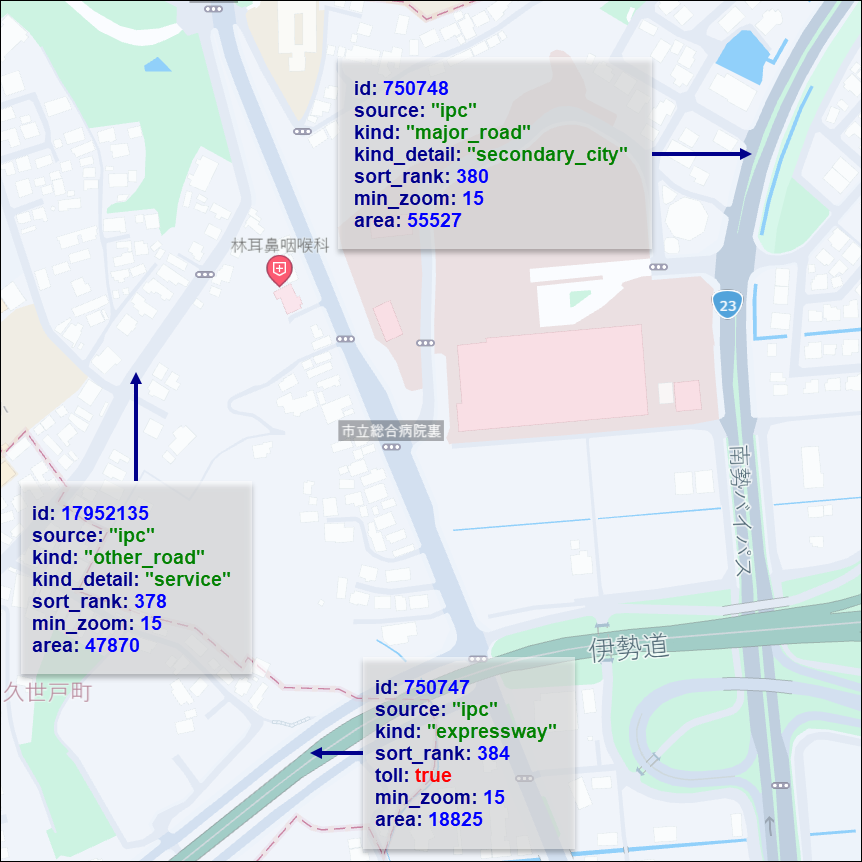
A polygonal road is a type of road for which a polygon is used to define the extent and shape of the road segment. Such roads are commonly used to depict roads that deviate from the traditional linear shape, such as roundabouts, cul-de-sacs, or curved road segments.
The core map in Japan-specific polygonal roads contains kind values with limited coverage at zoom 14 and higher, which allow for a detailed polygonal representation of roads. These values can be found in the is_present_in_landuse property of the roads feature. For more information, see Roads.
The following figure shows sample landuse features representing polygonal roads in Japan:
| Value | Geometry | Zoom | Description |
|---|---|---|---|
expressway | polygon | 14–17 | Expressway roads like motorway, also present as centerlines in the roads layer. |
major_road | polygon | 14–17 | Roads like secondary, also present as centerlines in the roads layer. |
national_road | polygon | 14–17 | Roads like primary, also present as centerlines in the roads layer. |
other_road | polygon | 14–17 | Roads like tertiary, also present as centerlines in the roads layer. |
road_in_restricted_area | polygon | 14–17 | Roads in restricted areas like parks, pedestrian areas, or golf courses, not present as centerlines in the roads layer. |
urban_expressway | polygon | 14–17 | Urban expressway roads like motorway, also present as centerlines in the roads layer. |
Values specific to decorative lines in Japan - core map
Decorative lines are linear features that are used to enhance the visual representation of certain elements on the map. These lines are not meant to represent actual physical features but rather serve as visual cues to help users better understand the layout and structure of the map.
| Value | Geometry | Zoom | Description |
|---|---|---|---|
decorative_buffer_stop | line | 14–17 | Buffer stops. |
decorative_center_divider | line | 14–17 | Center dividers. |
decorative_dashed_line | line | 14–17 | Dashed lines such as tunnel edge lines. |
decorative_expressway | line | 14–17 | Expressway edge lines. |
decorative_ferry_route | line | 14–17 | Ferry routes. |
decorative_passenger_boat_route | line | 14–17 | Passenger boat routes. |
decorative_railroad_overpass | line | 14–17 | Railroad overpasses. |
decorative_road_background | line | 14–17 | Road backgrounds. |
decorative_road_overpass | line | 14–17 | Road overpasses. |
decorative_road_surface_or_stairs_line | line | 14–17 | Road surface or stairs lines. |
decorative_solid_line | line | 14–17 | Solid lines. |
decorative_stairs_line | line | 14–17 | Stairs decorative lines. |
erosion_control_dam | line | 14–17 | Erosion control dams. |
flood_gate | line | 14–17 | Flood gates. |
toll_gate | line | 14–17 | Toll gates. |
kind_detail
Type: string
Present when kind is: low_emission_zone, major_road, national_road, other_road
Additional details about the landuse kind. For more information, see Additional kind information.
Values
| Value | Description | Associated kind |
|---|---|---|
congestion | For congestion zones. | low_emission_zone |
environmental | For environmental zones. | low_emission_zone |
Values specific to Japan - core map
| Value | Description | Associated kind |
|---|---|---|
primary | For national_road kind. | national_road |
secondary_city | For major_road kind. | major_road |
tertiary | For major_road kind. | major_road |
tertiary_city | For major_road kind. | major_road |
service | For other_road kind. | other_road |
area
Type: int
Optional
The area of the landuse feature in square meters. This property is valid for polygon features only.
Note
Area values measured in spherical Mercator projection are increasingly distorted at higher latitudes (for example, features near the poles will have inflated area values compared to their true geodesic area).
name
Type: string
Optional
The common local name for the landuse feature, in the local language script. For more information, see Feature names.
name:{language_code}
Type: string
Optional
The name of the feature in the specified language. If no data is available for the requested language code, the value may be compiled from an English or Latin transliteration of existing language representations. For more information, see Name localization.
translit:{language_code}
Type: string
Optional
The localized transliteration of the default name (name). For more information, see Name localization.
Properties specific to Japan - core map
toll
Type: flag
Present when kind is: expressway, other_road, urban_expressway
An optional boolean property that indicates if a fee must be paid by general traffic to travel the feature. This property can only have the following values: true and is available only for such polygonal road kinds as expressway, urban_expressway, and other_road.
Common properties
min_zoom
See min_zoom.
sort_rank
Type: int
Always present
The ordering of features, which determines which features are rendered "on top of" other features, can be an important issue when rendering maps. To assist map rendering, there is a sort_rank property on some features that suggests in what order the features should appear.
A feature with a higher sort_rank value is displayed on top of feature with a lower sort_rank value.
Values
Values specific to Japan - core map
Common properties specific to Japan - core map
source
See source.
Updated 3 months ago