Transit layer for Japan (deprecated)
Note
The
transitlayer as a part of default content is deprecated in favour of a new transit layer.You can request the new transit layer format by adding the following parameter to your query:
content=default,transit. For more information, see Optional content.
The transit layer provides information about public transportation systems, such as buses, trains, subways, and other modes of public transit. The features of this layer enable developers to integrate public transit data into applications or services, allowing users to plan routes, view schedules, and obtain real-time information about public transportation options.
Note
The
transitlayer features are currently available only for the Japan region as part of thecoremap parameter.
The following figure illustrates sample features of the transit layer rendered from the data:
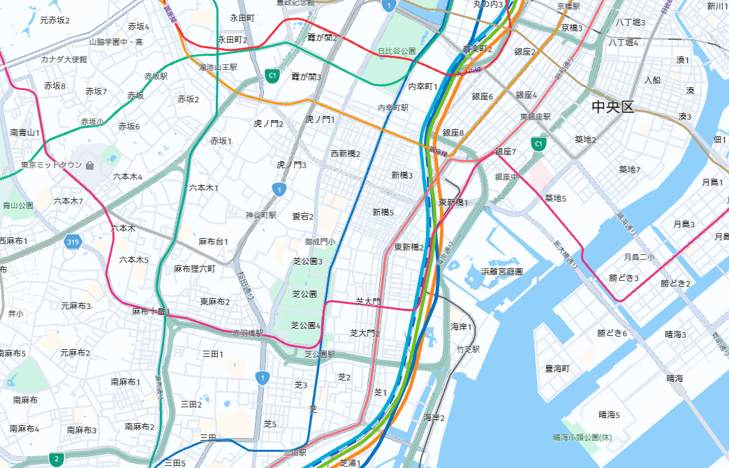
The layer content has the following definition:
- Layer name:
transit - Geometry types:
polygon,line
Transit line features become visible from zoom level 7 onwards, while platform polygons are added at zoom level 14 and higher. To optimize efficiency, features with the same line geometry, kind, and kind_detail are consolidated. This consolidation allows the storage of transit routes, colors, and color names in properties like all_ref, all_colour, and all_text_colour.
Shared properties
Every feature in the transit layer includes a set of properties that define it, regardless of the specific transit type it represents.
Note
These properties are referred to as
commonproperties in the Tilezen schema. For more information, see Tile layers.
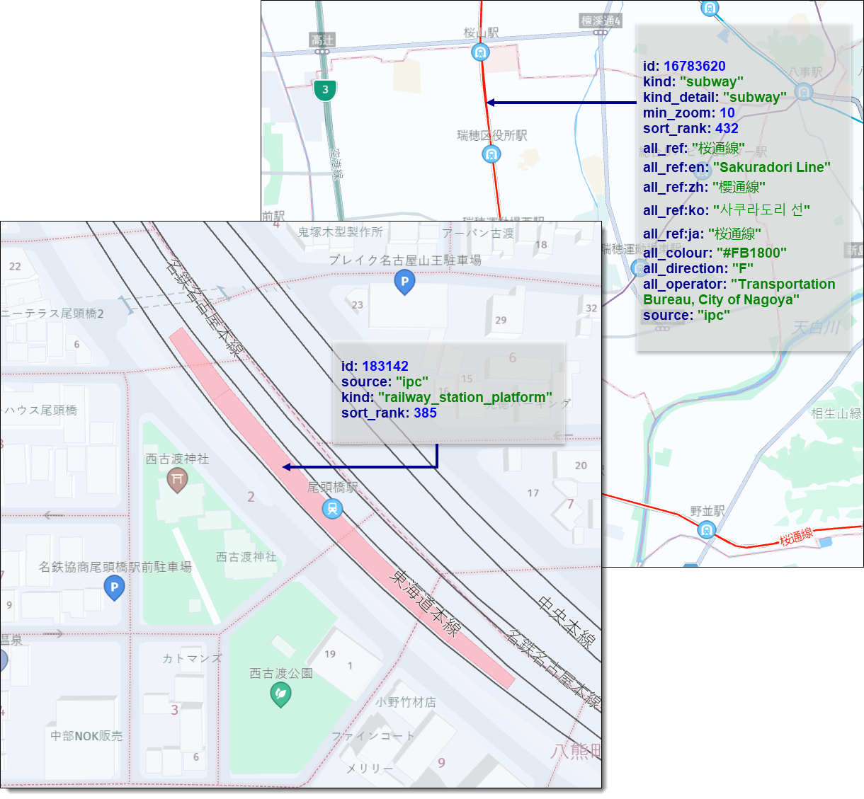
Consider the following sample parameters for a transit feature in Japan:
...
"kind": "train",
"kind_detail": "intercity",
"min_zoom": 8,
"sort_rank": 436,
"all_ref": "東北本線;宇都宮線",
"all_ref:en": "Tohoku Line;Utsunomiya Line",
"all_ref:zh": "東北本線;宇都宮線",
"all_ref:ko": "도호쿠 본선;우쓰노미야 선",
"all_ref:ja": "東北本線;宇都宮線",
"all_colour": "#00BB85;#FF871C",
"all_direction": ";F",
"all_text_colour": "#00BB85;#FF871C"
"all_operator": "Main Line;Main Line",
...
In the context of this example, consider the following transit feature properties:
kind- The general type of transit feature.kind_detail- This property provides additional details about thekindof transit feature. This parameter is relevant only within the context of thelinegeometry type.min_zoom- The recommended minimum zoom level at which thetransitfeature should be displayed.sort_rank- A value used to prioritize the display order of different types of transit features on the map. A transit feature with a highersort_rankvalue is displayed on top of a transit feature with a lowersort_rankvalue.all_ref- A semicolon-separated list of all the routes valid on this transit feature. In the example, the train line has two routes:"東北本線"and"宇都宮線". This parameter is relevant only within the context of thelinegeometry type.all_ref:*- Localized reference values for all the routes. For example, in English, the routes from the example are referred to as"Tohoku Line"and"Utsunomiya Line". The same routes are also provided in other languages as identified by ISO 639-1 two-letter language codes.all_colour- A semicolon-separated list of hex values representing the colors for the routes valid on this line. For example,all_colour="#00BB85;#FF871C". The first color#00BB85corresponds to the東北本線(Tohoku Line) route, and the second color#FF871Ccorresponds to the宇都宮線(Utsunomiya Line) route.all_direction- The parameterall_directionspecifies all the directions of the routes that are valid on a particular line. The values are provided as semicolon-separated values. The following conventions are used:Frepresents the forward direction of the route.Brepresents the backward direction of the route.- An empty value indicates that the route has both directions.
The direction values correspond to the values of the all_ref parameter, and they are matched in the given order.
For example, if all_direction is set to ";F", as shown in the example, it means that the Tohoku Line route is valid in both directions, while the Utsunomiya Line route is valid only in the forward direction.
This parameter is relevant only within the context of the line geometry type.
all_text_colour- Colors used for drawing the text of reference values for the routes valid on this line. It follows the same format asall_colour. This parameter is relevant only within the context of thelinegeometry type.all_operator- A semicolon-separated list of operator IDs for the routes valid on this line. For example,all_operator="Main Line;Main Line". The first operator ID corresponds to the operator of the東北本線(Tohoku Line) route, and the second operator ID corresponds to the operator of the宇都宮線(Utsunomiya Line) route.
The following figure shows sample transit features, as rendered on map in the form of lines or polygons:
Japan-specific kind definitions and sort ranks in the core map
The following list provides Japan-specific kind values for transit layer features and their corresponding sort_rank values. These kind values are available only within the core map parameter.
For more information about the map parameters available in the HERE Vector Tile API, see Map Parameter.
railway_station_platform- (sort_rank: 385) - Platform of a railway station.subway_station_platform- (sort_rank: 385) - Platform of a subway station.funicular(sort_rank: 430) - A transportation system that uses cable-operated cars on steep inclines.monorail(sort_rank: 431) - A railway system where the trains run on a single rail.subway(sort_rank: 432) - An underground or elevated railway system typically found in urban areas.light_rail(sort_rank: 429, 433) - A type of urban rail transit that operates with light capacity and shares tracks with other vehicles. The actualsort_rankvalue depends on the specific kind_detail for this feature instance.train(sort_rank: 435, 436, 437) - A general term referring to a mode of transportation that runs on tracks, typically used for intercity or regional travel. The actualsort_rankvalue depends on the specific kind_detail for this feature instance.aerial(sort_rank: 442) - A transportation system that operates above ground level, such as an aerial tramway or gondola.
Additional kind information for Japan-specific feature kinds
These kind_detail values provide additional information about the transit feature type in Japan, within the core map parameter.
For more information about the map parameters available in the HERE Vector Tile API, see Map Parameter.
tram(sort_rank: 429) - Represents tram lines for thelight_railkind.suburban(sort_rank: 433) - Indicates suburban rail lines for thelight_railkind.funicular(sort_rank: 430) - Indicates funicular lines for thefunicularkind.monorail(sort_rank: 431) - Denotes monorail lines for themonorailkind.subway(sort_rank: 432) - Represents subway lines for thesubwaykind.regional(sort_rank: 435) - Denotes regional railroad lines with thetrainkind.intercity(sort_rank: 436) - Represents intercity railroad lines with thetrainkind.high_speed(sort_rank: 437) - Indicates high-speed railroad lines with thetrainkind.aerial(sort_rank: 442) - Denotes aerial cable car or gondola lines for theaerialkind.
Next steps
- For more information about other layer feature types available in the HERE Vector Tile API, see Tile Layers.
Updated 6 days ago