

Why Do HERE Digital Terrain Models Elevation Values Differ from GPS Ellipsoidal Heights?
Symptoms
--------
Customers using HERE Digital Terrain Models (DTM) may report the following:
Elevation values do not match GPS-derived altitude values.
Heights differ from applications reporting WGS84 ellipsoidal elevations.
Elevation values appear offset when compared with GNSS measurements.
Confusion about whether DTM elevations are referenced to mean sea level.
Uncertainty about converting DTM elevations to WGS84 ellipsoidal heights for geospatial analysis.
Answer
------
HERE Digital Terrain Models (DTM) provide elevation values as orthometric heights above the EGM96 geoid, which closely approximates mean sea level. The elevations are not referenced to the WGS84 ellipsoid.
As a result, DTM elevation values can differ from GPS or GNSS measurements that report ellipsoidal heights referenced to the WGS84 ellipsoid.
Root Cause
----------
Different systems use different vertical reference datums.
HERE Digital Terrain Models use:
Orthometric Height (H): Height above the EGM96 geoid (approximately mean sea level).
Many GPS and GNSS receivers report:
Ellipsoidal Height (h): Height above the WGS84 reference ellipsoid.
The two values are related through the geoid separation:H = h - N
where:
H = Orthometric height (EGM96)h = Ellipsoidal height (WGS84)
N = Geoid separation
Because geoid separation varies by geographic location, the difference between DTM elevations and WGS84 ellipsoidal heights is not constant worldwide.
Impact
------
Failure to account for the vertical datum may result in:
Apparent elevation discrepancies when comparing DTM data with GNSS measurements.
Incorrect altitude calculations in applications that mix vertical reference systems.
Confusion when validating terrain data against GPS-derived heights.
Misalignment between datasets using different vertical datums.
Expected vs. Unexpected Behavior
--------------------------------
### Expected Behavior
HERE DTM elevations represent orthometric heights relative to the EGM96 geoid.
DTM elevations generally correspond to elevations referenced to mean sea level.
Differences may be observed when comparing DTM values with WGS84 ellipsoidal heights.
### Unexpected Behavior
Assuming DTM elevations are WGS84 ellipsoidal heights.
Directly comparing DTM elevations with GNSS ellipsoidal elevations without accounting for geoid separation.
Mixing EGM96-referenced and WGS84-referenced elevations in the same workflow without conversion.
Recommended Actions
-------------------
When comparing HERE DTM elevations with GPS, GNSS, or other elevation datasets:
1. Confirm the vertical datum used by each data source.
2. Determine whether the comparison is between orthometric heights (EGM96) or ellipsoidal heights (WGS84).
3. Apply an appropriate geoid conversion when converting between EGM96 orthometric heights and WGS84 ellipsoidal heights.
4. Ensure all datasets use the same vertical reference system before performing comparisons or calculations.
Additional background on ellipsoidal, geoid, and orthometric elevations is available here:
* The Difference Between Ellipsoidal, Geoid and Orthometric Elevations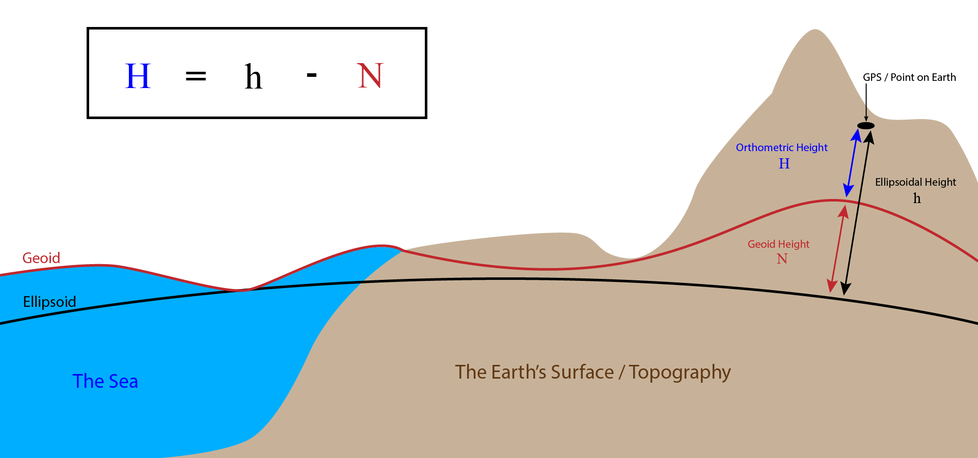
This package can be used to convert between EGM96-relative altitudes and WGS84 ellipsoid-relative altitudes: https://www.npmjs.com/package/egm96-universal
Keywords / Tags
---------------
HERE Digital Terrain Models, DTM, EGM96, orthometric height, mean sea level, MSL, elevation, altitude, terrain elevation, geoid, geoid height, vertical datum, WGS84, ellipsoidal height, GNSS, GPS, terrain data, topography, elevation reference system, digital terrain model
Updated 3 days ago